The Bari-Mola project


Valorising an area by building a road
The Adriatica SS 16 is the longest State road in Italy and is more than 1000 km long. It connects Padua to Otranto (Puglia) passing along the Adriatic coast and running through many Italian tourist places. It is very congested, especially near to large residential centres where the original route sometimes acts as a bypass.
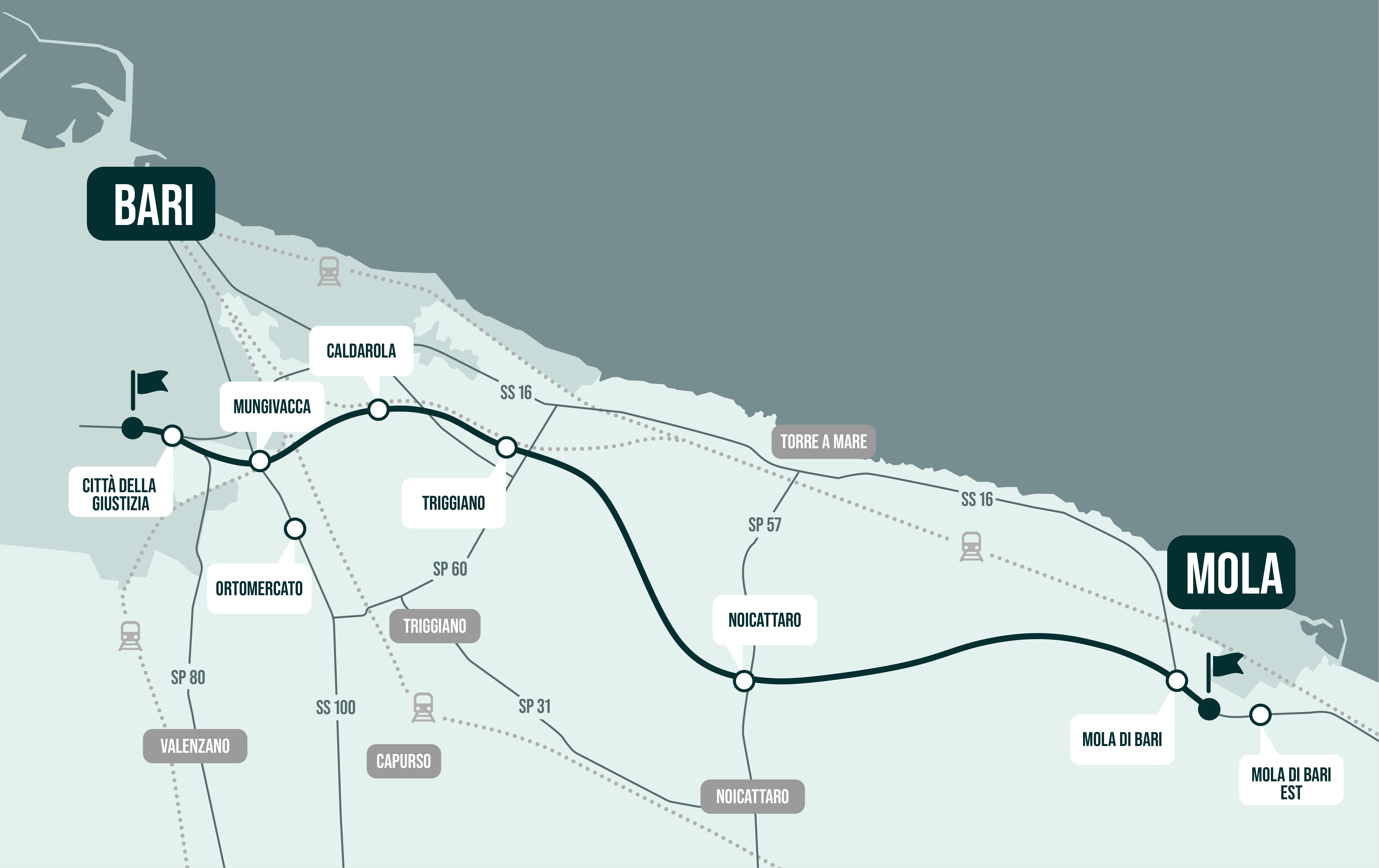
This is the case in Bari where the SS 16 reaches the limits of its capacity every day during rush hour.
In addition, since there are currently many critical points from the technical, functional and road safety points of view (no hard shoulder, traffic island in the middle does not comply with the law, unprotected direct accesses and off-road obstacles, and human settlements on the edge of the platform), ANAS decided that action had to be taken, planning a variant to the SS 16 with an overall length of 19.6 km in the section between the municipalities of Bari and Mola di Bari.
NET Engineering supported ANAS in drafting the Technical Economic Feasibility Project and was responsible for drafting the Final Design.
A multi-disciplinary project
Three alternative designs were analysed within the Technical Economic Feasibility Project. The main difference for the same road section was the plano-altimetric route because of the extension and features of the works and the interconnections and junctions with the existing road network. NET Engineering curated the draft of the transport study, the costs-benefit analysis and co-ordinated drafting of the environmental impact study so that the different design proposals could be carefully and effectively assessed and compared.
The transport study, created to estimate the effects of the new work on the mobility system, was divided into the following activities:
- Reconstruction of road mobility in the current scenario;
- Definition of the reference scenario for the timeline for activation of the work but without project intervention, to be used as a comparison scenario to assess the effects of the new infrastructure on mobility situations;
- Construction of the project scenario in the various configurations corresponding to the three alternatives analysed to prefigure the effects induced on road mobility by the new work;
- Extraction of summary transport indicators.
The costs-benefit analysis assesses the improvement that the fulfilment of a specific project generates on social well-being, allowing an assessment of the economic sustainability. It is therefore a tool which gives objectivity to the decision-making process, reducing the scope of controversy and subjective discretion and adopting criteria that allow respect for rules of general interest. If the benefits of a project exceed its costs, then it can be considered economically sustainable. The costs-benefit analysis for the SS 16 variant was carried out at the same time and in a completely comparable manner for all the alternatives so that not only the effective advantages the work could generate for the community could be assessed but also to find the best answer and so the one able to ensure the greatest benefits.
A structured analysis of the alternatives, from the strictly environmental point of view, was made in the scope of the environmental impact study. The methodology used for comparison is based on the assessment of sustainability of the different initiatives through a logical sequence. This starts from definition of the environmental objectives to be achieved and leads to determination of the balance of resources connected to the work through the schematisation of the work environment reports.
All the studies carried out by NET Engineering indicated the same design alternative as the best as it came closest to the preset objectives and reflected the environmental, social and economic sustainability criteria.
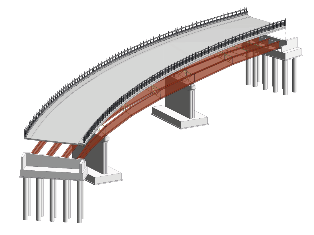
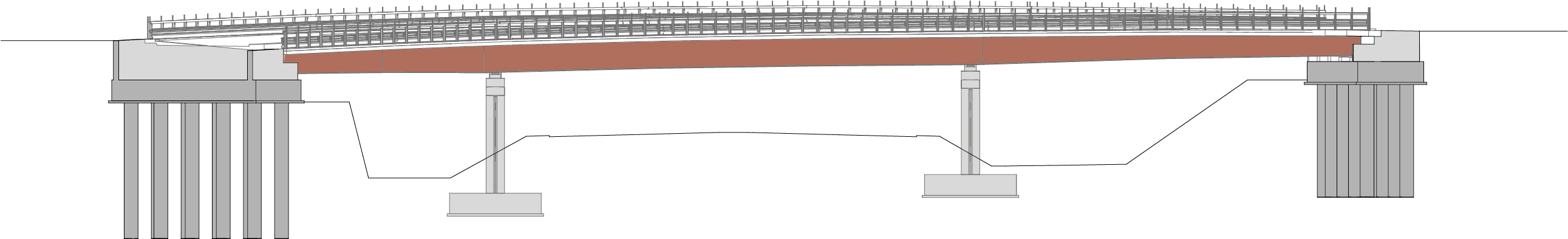
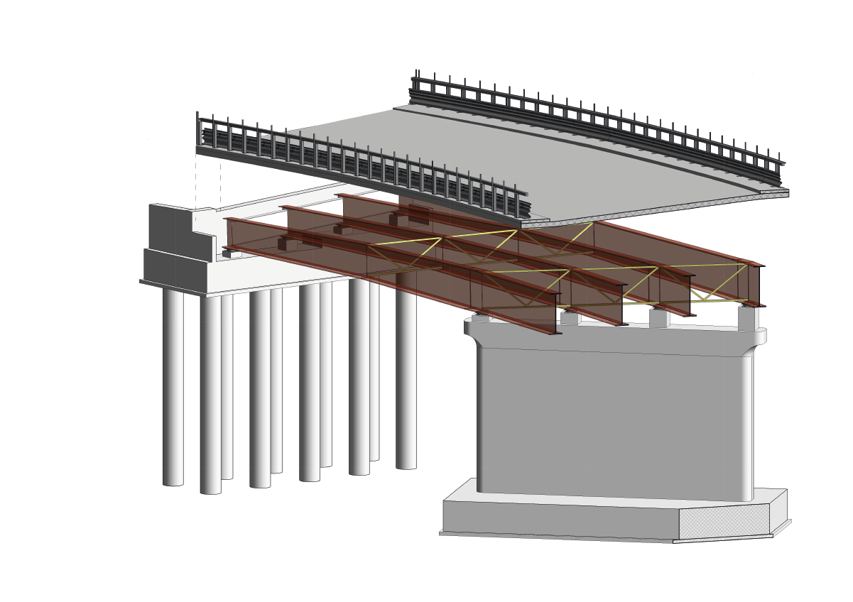
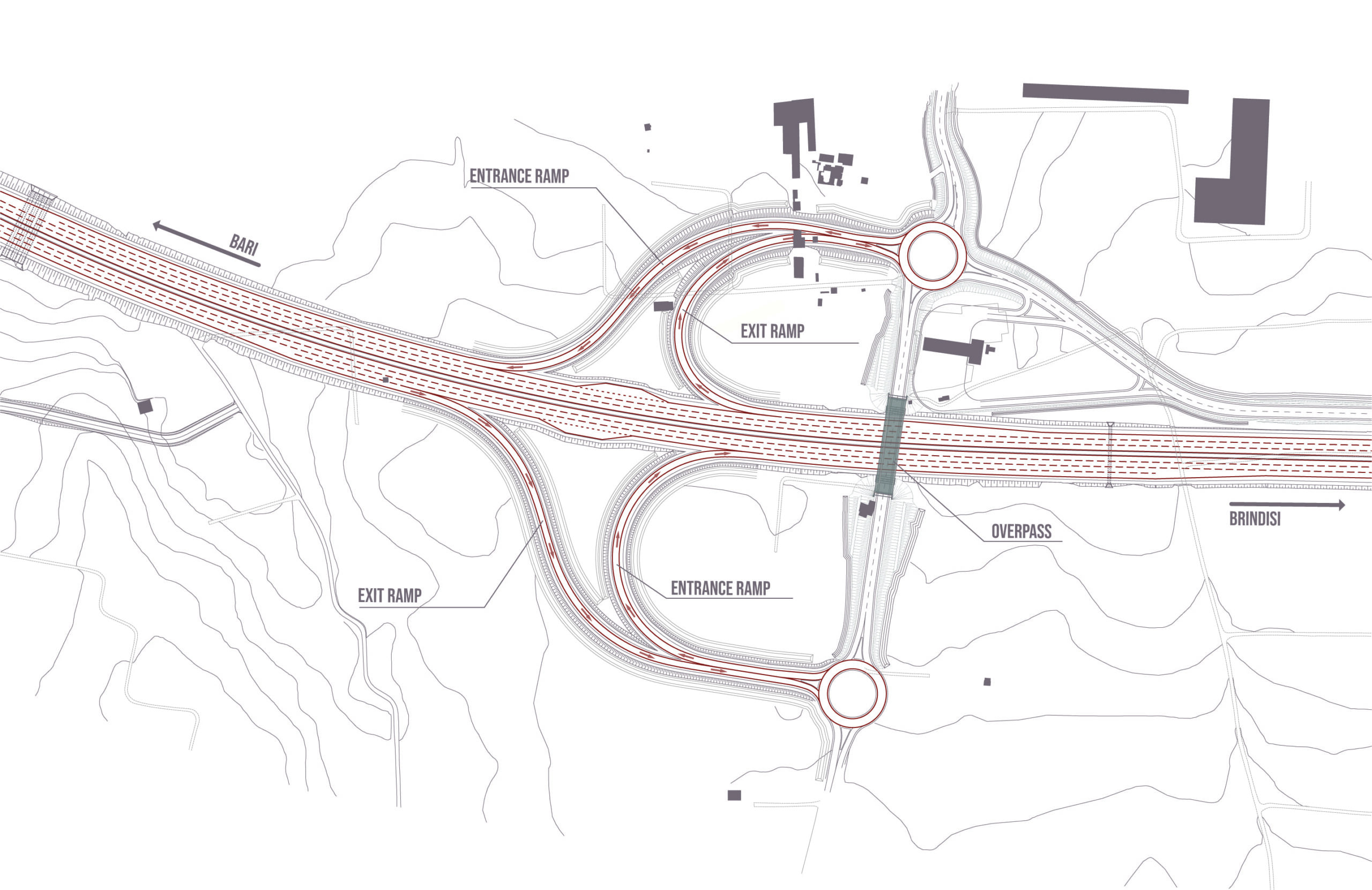
The alternative chosen, for which the Final Design was developed, sets out road infrastructure fully in the variant compared to the existing road with three lanes in each direction. The work planned along the variant includes seven junctions, some of which are especially complex, new entrance ramps, and updating and redevelopment of the existing sections with the aim of rationalising neighbouring local roads and increasing the usability of the new route. Further, in terms of the traffic system, the restoration of continuity of all the local roads involved through underpasses and overpasses of the new road infrastructure is planned.
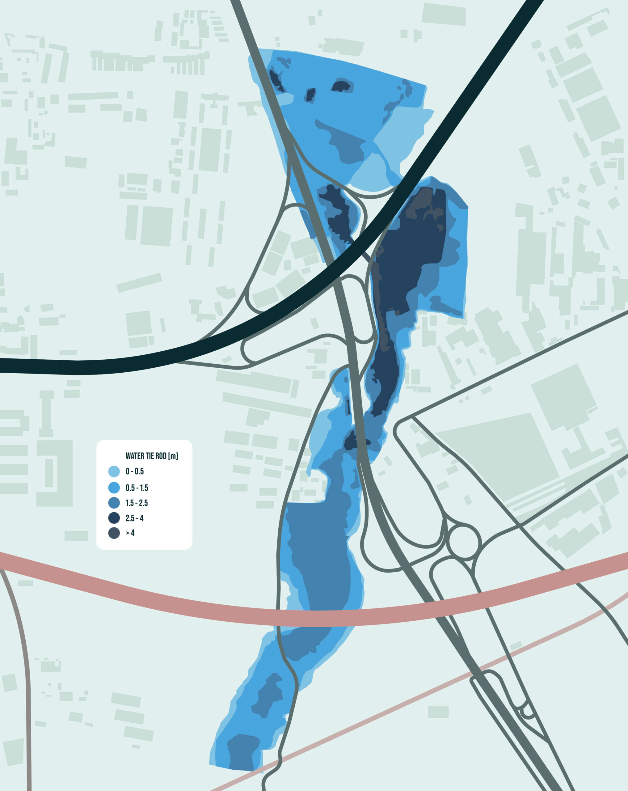
The route is more or less parallel to the coastline, meeting many main and secondary watercourses in the form of ditches. These are typical of the Bari area and have low surface circulation as most is underground. In addition, the ditches only have water when it rains otherwise they are mostly dry.
As the watercourses in the first part of the route near Bari are both hydraulically dangerous and risky, NET Engineering drafted careful hydrologic and hydraulic studies, developing single and two-dimensional modelling so that the hydraulic compatibility of the work could be assessed and the type and size of the hydraulic crossing works could be determined, ensuring compatibility of the work with the local context.
Attention to the area and stakeholder engagement
NET Engineering is supporting ANAS in the current public engagement process. This is a well-structured path aimed at the in-depth understanding of the specific requirements of the area, finding possible feasible solutions with stakeholders and significantly increasing acceptance of the new infrastructure by the population.
Discussions with the institutions and bodies involved started in the stages prior to development of the Final Design. All the area’s requests were accepted through work on ad hoc design solutions. To give some examples, the following were planned: sections of the road in cuttings not initially budgeted for, an in-depth study of the landscape impact and important environmental mitigation works, and analysis of the stages of the construction site so that the environmental impact could be reduced in terms of energy savings and attention to the natural resources in the context.
Therefore, the SS 16 variant will be a work careful to respect the vocation and morphology of the places it crosses, contributing to the reduction of urban pollution, improving accessibility of the area and increasing competitivity.