The Naples-Bari High speed line
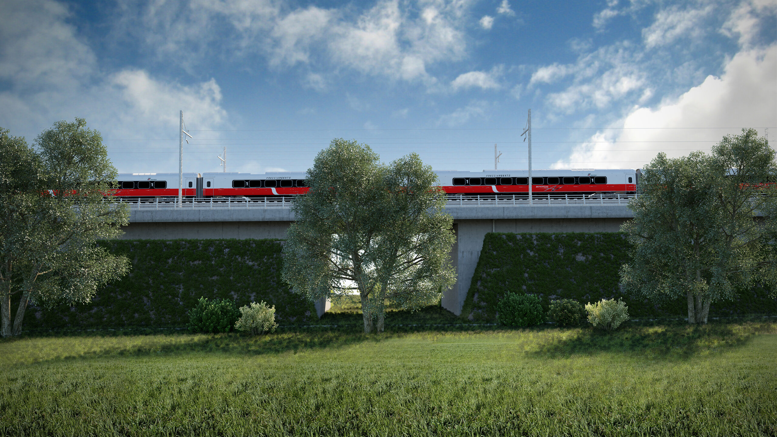


Technological innovation, multi-disciplinary and sustainable - the first large Italian infrastructure developed using BIM.
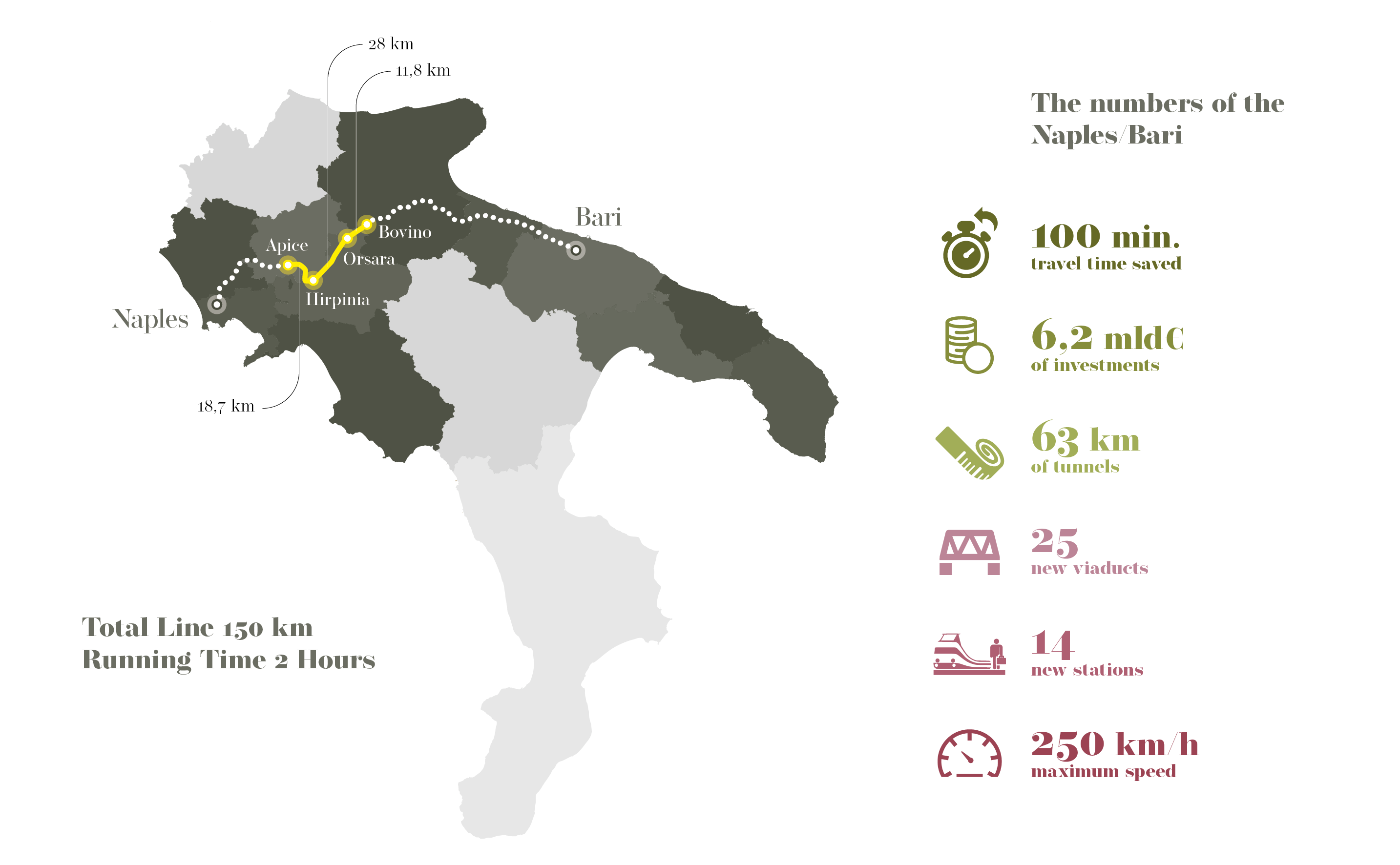
The High-Speed railway line connecting Naples and Bari is part of the wider redevelopment and optimisation programme for the Rome-Naples-Bari railway network. Functionally and structurally, this section will advance integration of the railway infrastructure of the South-East with the lines connecting to the north of the country and Europe. The project sets out the doubling of the single line railway sections and the creation of variants to the current scenarios, pursuing the solutions ensuring that connections will be speeded up and growth in the general railway service offer, at the same time increasing accessibility to the service in the areas crossed. The line, to be constructed in an especially challenging context environmentally, geotechnically and geomorphologically, will respect the highest safety standards in both the civil works and technology fields, e.g. by implementing Level 2 ERTMS-type signalling for the whole line.
In this context, NET Engineering took care of the Executive Plan for the Apice-Hirpinia, Hirpinia-Orsara and Orsara-Bovino sections, totally developed using BIM, with a figure for the work of more than Euro 2 billion. In addition to the planning and design it was responsible for, NET Engineering carried out co-ordination of the various players involved, created and organised the shared work environment, was the direct interface with the client, collecting and interpreting the requirements, and facilitated the discussions and integration between the different disciplines, setting out the project evolution times. In addition, NET Engineering also took care of the direct relationships with the construction company for the Apice-Hirpinia section, already under construction.
The planned routes
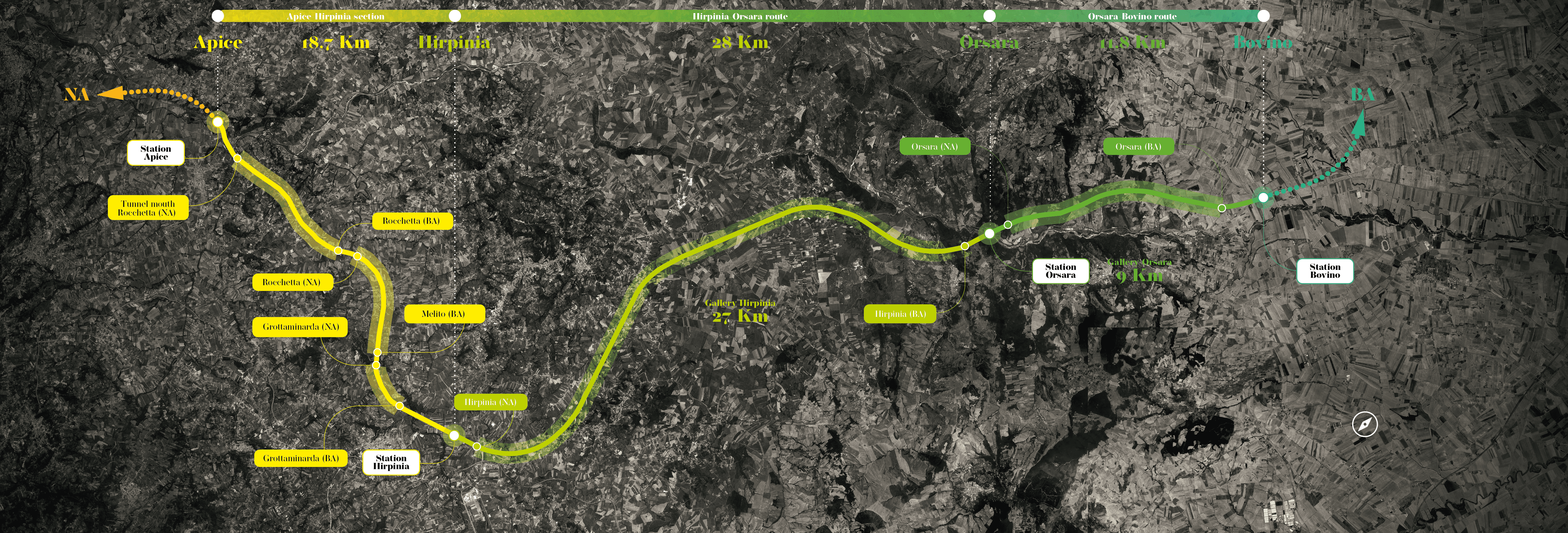
- Apice-Hirpinia (2019-on going)
- This section, already Envision Platinum certified, lies in Campania and crosses seven municipalities overall. The route, a complete variant compared to the ‘old’ line, will see the creation of a new two-track line with an overall length of 18.7 km and a design speed of 200 kph. The project includes not only the new stop at Apice and the new Hirpinia station but also four important viaducts (VI01 - 655 m, VI02 - 205 m, VI03 - 415 m and VI04 - 705 m), 16 new road sections, the building services and systems technologies. The Grottaminarda (1.9 km), Melito (4.4 km) and Rocchetta (6.4 km) tunnels, constructed using only mechanised excavation, will mean that about 70% of the section will be in tunnels.
- Hirpinia-Orsara (2021-on going)
- This section has an overall length of 28 km with a design speed of 200 kph near Hirpinia and Orsara stations and 250 kph for the remaining section, which is in a tunnel. The most interesting works are certainly the new Orsara station, VI01 viaduct (320 m) over the River Cervaro and the Hirpinia tunnel, 27 km long, which will be the longest railway tunnel in Italy (in a photo-finish with the base tunnel of the Tortona-Genoa High-Speed railway) and the 12th longest in the world. On the Bari side, the tunnel starts as a two-bore and continues in this way until the connecting chamber near the exit on the Naples side. Here, it becomes a single-bore tunnel with two tracks to allow connection to the run tracks of Hirpinia station.
- Orsara-Bovino (2021-on going)
- This section is mainly in tunnels with a speed of between 200 and 250 kph and an overall length of 11.8 km.
The main work is the Orsara tunnel (9.8 km). On the Naples side, there is a single tunnel with two tracks before reaching a chamber of 320 metres where the tracks gradually lead to a passage of 40 metres. From this point, there are two tunnels which, for geomorphological reasons, continue to diverge up to a distance of 50 metres. The route continues in the open, firstly in a cutting and then on an embankment, downstream from the tunnel on the Bari side.
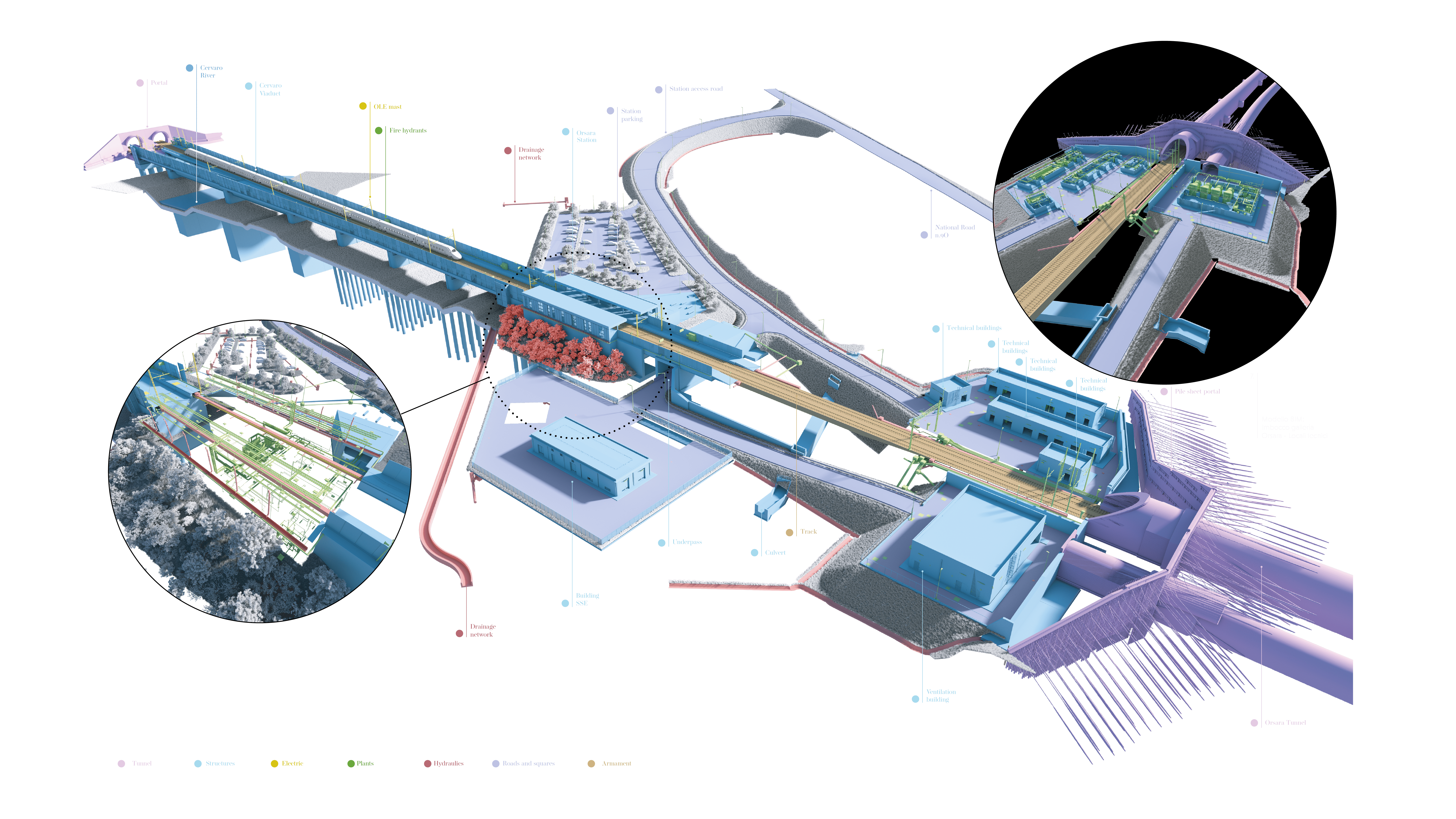
The first large Italian infrastructure developed in BIM
NET Engineering handled the creation and organisation of the shared work environment with the aim of developing the design of the three sections with BIM methodology. All the designers involved implemented the same macro-model on the Autodesk BIM360 platform for the best management of the inherent complexity of this type of project. This work method facilitated the transversal nature, discussion between the disciplines and exchange of information and skills, benefitting the design result. The BIM model also allowed the creation of the renderings and views necessary not only for the careful development of the project but also stakeholder involvement.
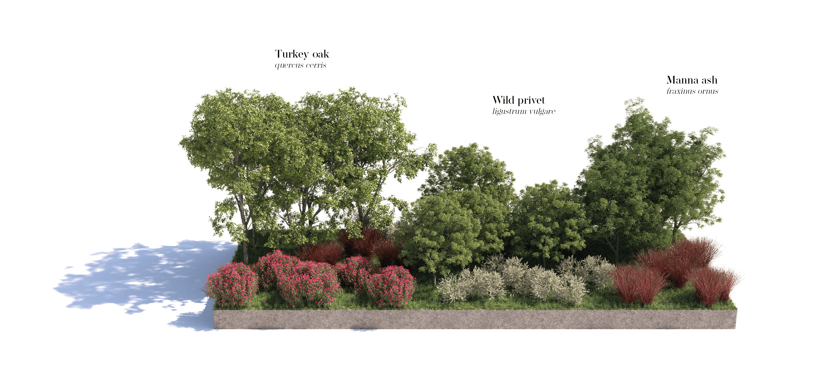
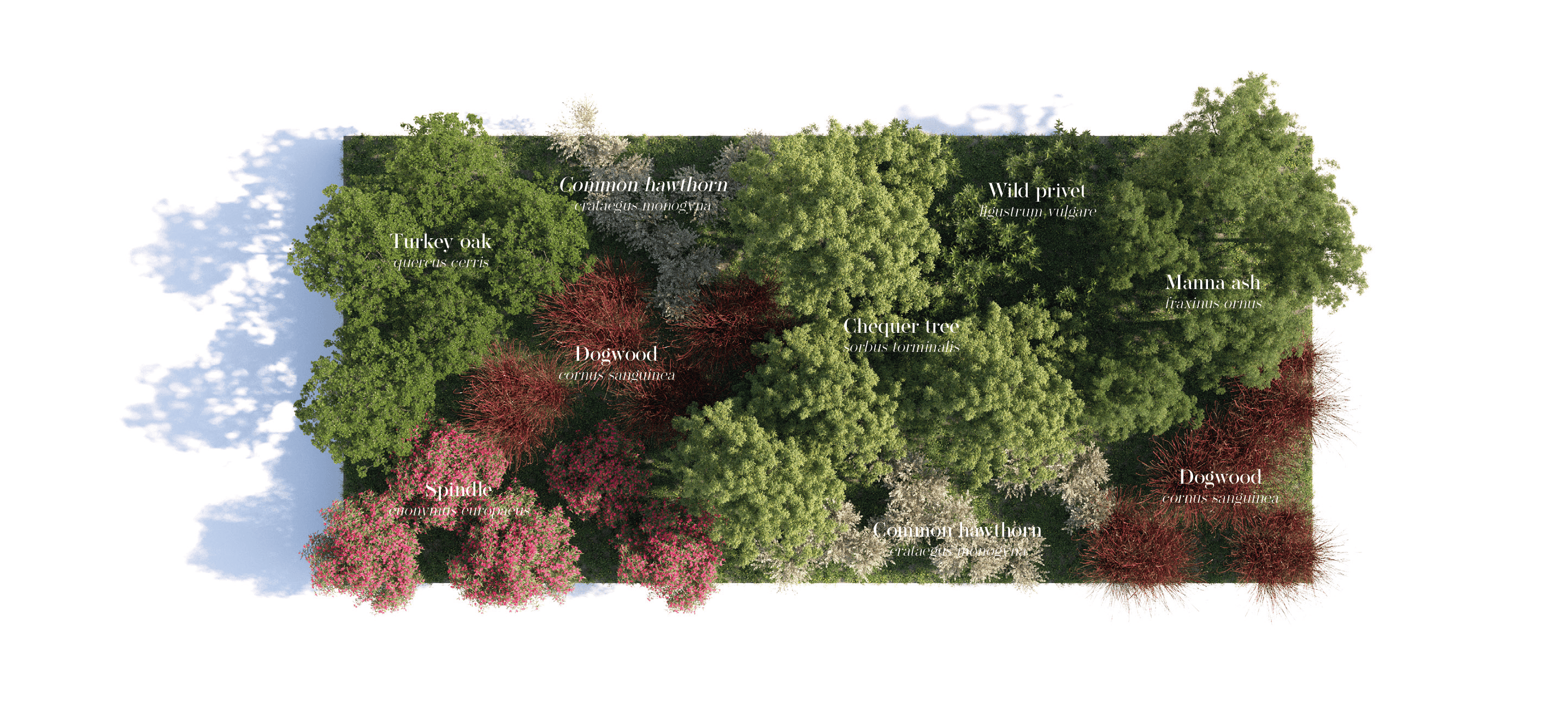
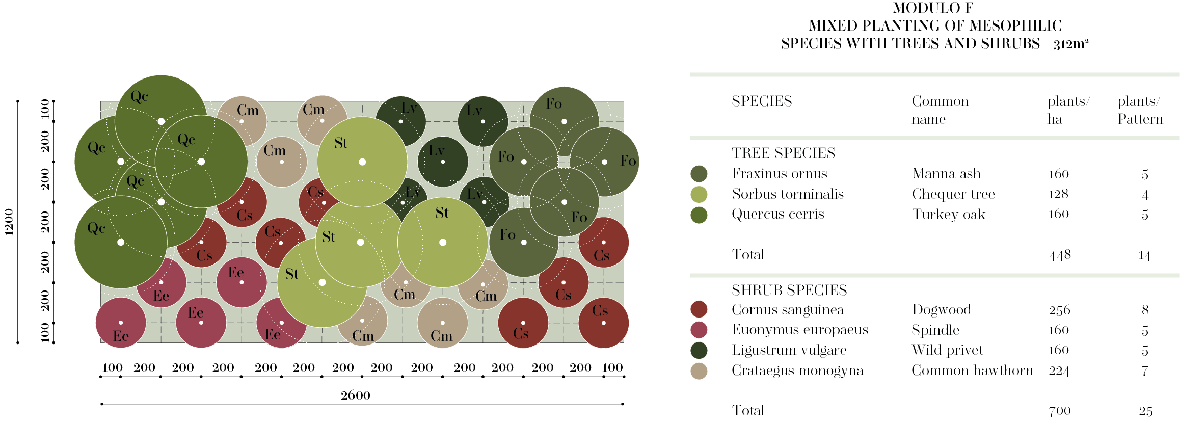
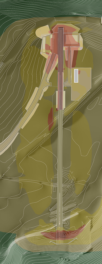
Environmental and landscape inclusion
Mitigation measures are mainly based on recovery of the areas directly involved by the project. Green areas are used to offer both aesthetic-perceptive redevelopment and reconstruct naturally important elements in a context mainly featuring natural and agricultural vegetation cover. On this point, special attention was given to the crossings of watercourses and the widespread obliteration of the agricultural fabric consisting of the design of the fields and the existing infrastructure. This led to the indication of targeted mitigation measures to establish a context between the project work and the agricultural landscape it is set into, minimising the superimposition effect.
Another aspect assessed related to the creation of areas where reinstatement of the previous agricultural use was not possible at the completion of the works. These areas were valorised through the introduction of natural elements.
The choice of the planned system modules was also aimed at achieving some specific objectives – the improvement in the quality of the landscape through the recovery of traditional shapes and screening of degraded areas, and the increase in ecological potential via interconnection.
Mitigation of construction sites in protected areas
Since some of the construction sites for building the Hirpinia-Orsara and Orsara-Bovino sections will be set up inside the Special Conservation Areas of the Natura 2000 network, NET Engineering took care of the design of specific mitigation measures setting out the use of plant material for harmonic inclusion with the least possible impact of the site areas in the landscape-environment.
The NET Engineering project was developed based on 4 strategic lines:
- Landscape inclusion of the site areas :
- Creation of wooded backdrops both internally and along the perimeter of the site areas, visual mitigation of the main systems, etc.;
- Ecological continuity of the river channel:
- Creation of connecting tissue and buffer zones along the perimeter of the site areas, diversification of habitats, use of naturalist engineering techniques, etc.;
- Mitigation of the impact on the fauna :
- Creation of systems-protection barriers for the fauna, environments favourable to the feeding and reproduction of the fauna, new corridors for fauna mobility, etc.;
- Reduction of the direct impact of site areas :
- Reduction of site surface areas, conservation of existing vegetation, repositioning in another site of the planned segment fabrication work, and use of conveyor belts for handling the spoil.
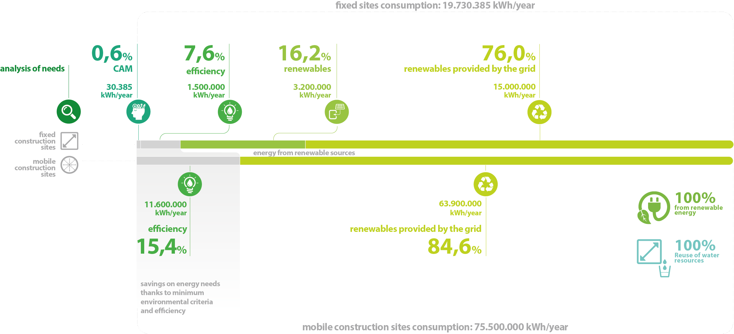
The sustainable construction site
Correct and complete implementation of the sustainable construction site within an infrastructural work can only be made with an overall approach strategy that develops through a succession of steps aimed at finding the best answers on the environmental impact of the construction site:
- Analysis of water and energy needs and indication of the reference legislative framework;
- Design solutions and construction methodologies with the least energy and water consumption – optimisation of work processes through design and construction solutions needing the least energy and water consumption;
- Water and energy efficiency solutions – indication of both structural and systems efficiency solutions that will allow the same performance objectives to be attained with a less demanding energy and water balance;
- Use of in situ water and energy sources – this will prevent a contribution to the increase of the site’s environmental footprint due to supply from fossil energy sources, using (only by way of example) the drainage water from the excavation face for the water requirements of the fully operational site, and solar energy (photovoltaic and solar thermal);
- Supply of sustainable energy for other needs.
Sonic boom
The study of the sonic boom carried out by NET Engineering in the sphere of the acoustic study for both the construction site stage and the operational stage is specially interesting. The sonic boom occurs as trains enter or exit a tunnel; the study further analysed the Hirpinia tunnel.
As the mouth of the railway tunnel is a very complex sound source, two technical-practical methods were compared for the simulation of the emission in the forecasting model – use of the proprietary algorithm in the Soundplan software and the application of a more experimental method derived from the indications in the ISPRA Technical Report of the POD of 2009, a research project on the emissions at the mouths of tunnels on HS/HC lines. The comparison between the results of the two methods showed minimal deviation thus confirming the reliability of the forecasting software algorithm adopted in the operational acoustic study.